Mapnik 4.2.1 Release Jan 28, 2026 | Artem Pavlenko
Mapnik 4.2.0 Release Dec 30, 2025 | Artem Pavlenko
Mapnik 4.1.4 Release Nov 06, 2025 | Artem Pavlenko
Mapnik 4.1.3 Release Oct 01, 2025 | Artem Pavlenko
Mapnik 4.1.2 Release Aug 03, 2025 | Artem Pavlenko
Mapnik 4.1.1 Release Jun 27, 2025 | Artem Pavlenko
Mapnik 4.1.0 Release Jun 01, 2025 | Artem Pavlenko
Mapnik 4.0.7 Release Apr 05, 2025 | Artem Pavlenko
Mapnik 4.0.6 Release Mar 02, 2025 | Artem Pavlenko
Mapnik 4.0.5 Release Jan 31, 2025 | Artem Pavlenko
Mapnik 4.0.4 Release Dec 04, 2024 | Artem Pavlenko
latest news
Custom maps with Mapnik (part 2)
Feb 22, 2008
The people behind OSM Cycle Map have recently added contours. Combining contours with street level data is no trivial task, but Andy and Dave yet again have come up with an attractive solution. If you're a cyclist you know how important it is to see if you're going to be heading up or downhill!
There are some very nice examples on their site, do check them out.
I was looking for places I cycled in the past and here is my favourite for today:
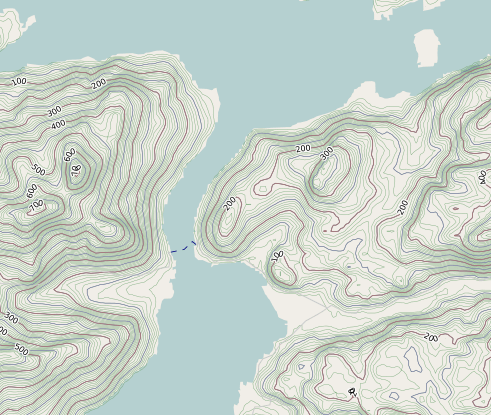
It hasn't been mapped by OSM yet, but there is a lovely cycle route you might try. Starting from the mainland (Glenelg), cross by the small car ferry to Skye. Head straight up the valley in front of you - where you might feel those contours in your legs - and on over the hills till you hit the A87. There are great views on the way (weather permitting). Turn right and back to the mainland (Kyle of Lochalsh) over the (ex)Toll bridge.